The then $10 million project (built in 1898) was the product of British financing, American engineering and Canadian contracting
By Bala Menon
The White Pass and Yukon Route narrow gauge railroad in Skagway, Alaska, is certainly one of the most scenic railways of the world.
From its more than 100-year-old carriages, with its picture windows, riders get a panoramic view of the grandeur of the Alaskan mountains and the awesome wilderness of this frontier land. The pass goes through the Boundary Ranges of the Coast Mountains between the Alaskan and British Columbia borders.
The railroad links the port of Skagway with Whitehorse in Yukon, Canada, and dates to the time of the famed Klondike Gold Rush of the late 19th century.

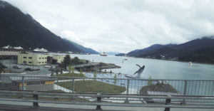
The port of Skagway on the Alaskan Panhandle is a popular halt for cruise ships travelling the Inside Passage along the coastal route from Seattle and Vancouver… (There is no land access to Skagway… it has to be through the port or by small aircraft. We reached Skagway aboard the Holland America Line’s cruise ship The Volendam).
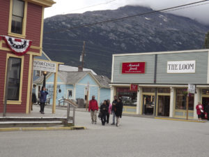
Although the borough of Skagway has a population of only around 1,500 during normal times, it comes alive during the summer tourist season and it is estimated that almost one million people pass through the town every year to soak in the history of its legendary mining past.
Skagway has been the setting for several books and films including Jack London’s memorable classic, featuring a husky named Buck – ‘The Call of the Wild’. The John Wayne 1960s film ‘North to Alaska’ was also filmed there.
Wikipedia says: “The name Skagway is derived from shԍagéi, a Tlingit (indigenous peoples of the Pacific Northwest Coast) word which figuratively refers to rough seas in the Taiya Inlet, caused by strong north winds. (Taiya Inlet is an estuary which lies in a deep valley, with Skagway at its north end.)
One of the exhibits in the small museum in Skagway reads: “Follow in their Footsteps: Walk where gold seekers, gamblers, dreamers and entrepreneurs once walked. Today, you can experience the gold rush era through the places and stories preserved by the National Park Service,: the gold rush boomtowns of Skagway and Dyea; the trails that gold seekers took – Chilkoot and White Pass and the photographs, artifacts and memories of a great human drama.”
Let us delve into a little history. An American adventurer George Carmack and his wife Kate (who belonged to the Tagish First Nation), her brother Skookum Jim and her nephew Dawson Charlie struck gold in the Bonanza Creek area of the Klondike region in the Yukon in 1896… It was not a big quantity, but word reached Seattle and San Francisco and soon newspapers across the United States had screaming headlines about massive goldfields up north.

This was the second time in the 19th century that gold fever was hitting the US. In 1857 gold was discovered in the Fraser River and some 800 ounces of gold was sent to the San Francisco Mint by James Douglas (who later became the first Governor of British Columbia)
This was the first gold rush – with over 30,000 prospectors, some dreamy-eyed, some crazed, from California, Mexico, Australia, Europe and China heading to Victoria and New Westminster and stampeding up the Fraser and into the dense wilderness of British Columbia to reach the Fraser and Cariboo goldfields.
____
History repeated itself when the Klondike gold was discovered. It is said that people in the US abandoned their jobs, homes and families to travel north – and most had no idea of the deadly bite of Canadian winters.
Official reports from those days say over 100,000 men embarked on the perilous journey from the Alaskan coastal towns of Skagway and Dyea to traverse the Yukon River and then sail on to the Klondike River, a distance of some 4,000 kilometers.
Only 30,000 reached their final destination of Dawson City, many being forced to turn back sick and hungry or killed en route on the treacherous ice-bound routes. There were two ways to Dawson City – one the famous Chilkoot Trail from the town of Dyea, which was shorter but steeper and more forbidding and the White Pass Trail from Skagway, which had its own set of dangers of narrow, snowy mountain paths and rockfalls…
After reports of deaths reached the authorities, the Canadian government acted to ensure their survival. It was made mandatory that each miner carries supplies enough to last a year. The list included 150 lbs. of bacon, 400 lbs of flour, 15 lbs. salt, 2 pairs of heavy trousers, a coffee pot and 1 dozen heavy wool socks…amounting to around 2000 lbs of supplies.

The wealthier adventurers hired other miners or bought pack horses to cover the route. On the White Pass Trail, hundreds of these animals perished through sheer exhaustion and one of the landmarks is named Dead Horse Gulch.
Of the 30,000 who reached Dawson city and the goldfields, only 4000 found gold and only a few hundred struck it rich. Hundreds more died in fires that raged often across shanty towns and in epidemics.
Other routes through Alaska and Alberta to the Yukon also attracted thousands of people, with hundreds perishing in the cold, trying to cross glaciers and later getting lost in the immense wilderness.
Work on the railroad from Skagway began in 1898 at the height of the Alaskan-Klondike Gold Rush to prevent deaths of miners on the route and allowing them a safer passage instead of hiking the route on foot. However, the rush ended soon after when gold was discovered further afield and both Skagway and Dyea became ghost towns.
The White Pass Yukon Route narrow gauge railroad was in 1994 designated as an International Historic Civil Engineering Landmark, a unique honour shared with the Panama Canal, the Eiffel Tower and the Statue of Liberty.
The WPYR website says: “The $10 million project was the product of British financing, American engineering and Canadian contracting. Tens of thousands of men and 450 tons of explosives overcame harsh and challenging climate and geography to create ‘the railway built of gold.’
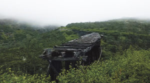
The railroad was completed in 1901, along with a steel cantilever bridge (which was the highest in the world at the time) and which was abandoned in 1969. We can see this ‘bridge to nowhere’ standing forlorn on the route today.
From the late 1980’s until now the railroad has been used as a tourist draw. The classic train winds across 108 km to an elevation of 3000 feet “in just 32 km and features steep grades of up to 3.9%, cliff-hanging turns of 16 degrees, two tunnels and numerous bridges and trestles.”
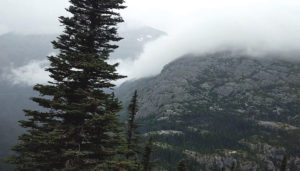
We can see deep canyons, rushing streams in the valleys a thousand feet below and majestic waterfalls like the Bridal Veil falls cascading from the mountains topped by mini glaciers as the train climbs into the clouds.
We pass landmarks like Rocky Point, Porcupine Point and Tunnel Mountain. From Rocky Point, where the trail veers sharply to the right, we can glimpse for a few minutes the famous Lynn Canal (one of the deepest and longest fjords in the world) and Mount Harding.
The old route covered 176 km from “Skagway to Whitehorse in the Yukon and on to northwest Canada and interior Alaska. Today, the WP&YR is Alaska’s most popular shore excursion carrying over 400,000 passengers from May to September operating on the first 108 kms (Skagway, Alaska to Carcross, Yukon) of the original line.” (Source: wpyr.com) The Chilkoot trail has become a popular, but grueling hiking route in the summer.